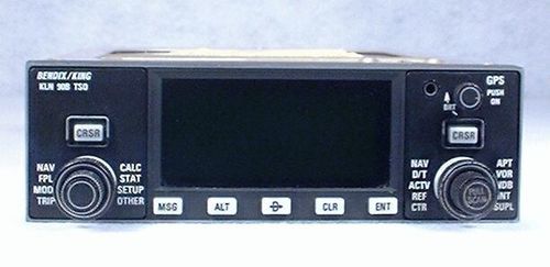
King KLN-90B IFR-Approach GPS / Moving Map
AMERICA North (USA-Canada-Mexico)
King's KLN-90B IFR-Approach Capable GPS is a "best-of-breed" GPS solution. It is approved for IFR en route, terminal, and non-precision approach use. It is this capability to fly approaches that distinguishes it from the competition. The KLN-90B's ability to show both approach information and a moving map simultaneously helps reduce the workload and boost situational awareness during the busiest phase of flight. Add to this a comprehensive Jeppesen database, and the KLN-90B offers a terrific blend of flexibility, information, and ease-of-use. Adding a KLN-90B to your panel will help you fly with better precision, greater information, and improved safety. The KLN-90B has many great features, including:
Bright 3-inch green high resolution CRT display - This display is easy to read in any light and from any angle. In addition, it allows the pilot to see up to seven lines of information at once without scrolling.
Moving Map graphics - The map shows aircraft position relative to surrounding database items (including approach waypoints).
Flexible operations - The CRT display may be "split" into two independently-controlled pages, allowing the pilot to tailor the information presented to the current situation. In addition, one of the pages may be the moving map, allowing the aircraft's progress and position to remain displayed while other functions are used.
Comprehensive Jeppesen database - The database includes SID and STAR waypoints, approaches, airports, navaids, intersections, minimum safe altitudes, flight service station and "Center/IFR" frequencies, special-use airspace, and airport services.
Pilot-focused design - The KLN-90B uses simple concentric knob controls (like other King products), provides the ability to store up to 26 flight plans with 30 waypoints each, and performs flight calculations including true airspeed,pressure altitude, density altitude, winds aloft, track, ETA, etc.
Compatibility - The KLN-90B may be interfaced with an HSI, CDI, Autopilot, and external Moving Maps.

