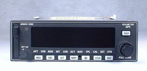
King KLN-89B IFR-Approach GPS / Moving Map
AMERICA North (USA-Canada-Mexico)
King's KLN-89B IFR-Approach Capable GPS is a powerful, yet affordable GPS solution. The KLN-89B's most outstanding feature is that it is approved for IFR en route, terminal, and non-precision approach use. This approach capability is normally only found in more expensive units. It accepts altitude input from an encoder for much improved vertical accuracy. (As great as GPS is for lateral navigation, its vertical navigation is not as precise.) The KLN-89B's ability to show both approach information and a moving map simultaneously helps reduce the workload and boost situational awareness during the busiest phase of flight. Add to this a comprehensive Jeppesen database, and the KLN-89B offers a terrific blend of flexibility, information, and ease-of-use. Adding a KLN-89B to your panel will help you fly with better precision, greater information, and improved safety. The KLN-89B features:
Large gas discharge display - This high visibility dot-matrix display provides great sunlight visibility, a wide viewing angle, and the same easy-to-read orange color found on the rest of your King Silver Crown avionics. This display can show four lines of text simultaneously, which shows more information with less scrolling.
Moving Map graphics - The map shows aircraft position relative to surrounding database items (including approach waypoints). This yields a tremendous boost in situational awareness.
Flexible operations - The dot-matrix display may be "split" into two pages, with waypoint or navigational data on the left and the map on the right. This allows an approach to be flown from a single screen, and enables you to monitor your progress throughout the approach.
Ease of use - The KLN-89B uses simple concentric knob controls, like other King products. There are clearly labeled pushbuttons with simple, consistent functions. The "Direct-To" button makes point-to-point navigation almost effortless. There are a full compliment of E6-B calculations available, designed to make the pilot's decisions easier and more accurate.
Peace of mind - An Emergency Search will describe and guide you to the 9 nearest airports, VORs, NDBs, intersections, or user waypoints. This ability is always available with the NRST (Nearest) button.
Comprehensive Jeppesen database - The database includes SID and STAR waypoints, approaches, airports, navaids, intersections, minimum safe altitudes (with vertical navigation functions), communications frequencies, special-use airspace, and airport services. This database is located in a front-mounted data card, allowing the pilot to update it easily. Additionally, the database has space for 500 user defined waypoints, and user comments for 200 airports.
Compatibility - The KLN-89B may be interfaced with a wide variety of electronics, such as an HSI, RMI, CDI, Autopilot, Fuel Flow Sensor, and external Moving Maps.

