Garmin
AMERICA North (USA-Canada-Mexico)
Brand: II Morrow / Garmin AT
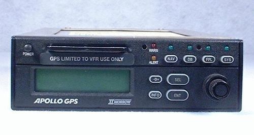
Apollo 820 Flybuddy VFR GPS Navigator
The Garmin AT (originally II Morrow) Apollo 820 Flybuddy GPS Navigator is a very solid GPS choice. This is an excellent GPS to consider if you are looking to replace an older II Morrow Loran-C. There is a clear family heritage, both operationally and physically. This unit is designed for direct plug-in replacement of II Morrow Loran-C products, including the 602, 604, 612, 618, and the Flybuddy 800 and 800+. When looking at the total cost of moving up to GPS, consider the installation costs that you will save with the Apollo 820 Flybuddy GPS. You will obviously need to replace your Loran Antenna with a GPS antenna, but the mounting rack and wiring remains the same. The Apollo 820 Flybuddy GPS features:
Backlighted LCD display - This display is designed to provide easy viewing, especially in direct sunlight. It shows two lines of information at once, and may be customized to display the most useful data fields. The display may also be configured to show an electronic CDI. The sensitivity of this CDI is also adjustable, and may be set to vary based on your distance from the desired track.
Ease of use - This GPS has a simple user interface, using two concentric knobs, a small number of buttons, and clearly defined operating modes. The Flybuddy GPS can save 100 user waypoints, either by entering the coordinates or by flying over the location and entering the Present Position. Up to 32 characters of comments may be added for each pilot-created waypoint. The pilot may create and store up to 10 flight plans of 11 waypoints each. The Flybuddy GPS also offers an elapsed timer and a countdown timer.
Peace of mind - An Emergency Search will find the 10 nearest airports.
Internal and data card databases - The internal database contains worldwide VORs and public-use airports. This database includes the Latitude/Longitude coordinates and State/Country identification for each waypoint (more than 13,000). It also holds local magnetic variation data for accurate, automatic compensation world-wide. There is also a North American database on a data card, which makes it much easier to keep up-to-date. This database has additional information for this region, including frequencies, runways, and field elevations. City names are also available, allowing waypoint retrieval by city name.
Compatibility - The Flybuddy GPS may be interfaced with an HSI, CDI, Blind Encoder, Moving Map, and Autopilot. Even though this GPS does not have an internal Moving Map, it may be used to provide position information to an external Moving Map.

